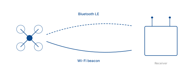
Drone Remote ID is a digital license plate for unmanned aircraft. Every compliant drone broadcasts its identity, position, altitude, speed, and operator location over Bluetooth LE and Wi-Fi. The Bluetooth Framework and Wi-Fi Framework capture those broadcasts on Windows and deliver them to your application as structured, standards-compliant telemetry.
Introduction
The rapid proliferation of commercial and recreational drones has created an urgent need for a standardized way to identify unmanned aircraft in flight. Airspace authorities, law enforcement, and private security firms face the same problem: an unidentified drone overhead, no way to link it to an operator. Remote ID closes that gap by mandating that drones broadcast their identification and telemetry continuously during operation.
The broadcast carries a unique identifier, three-dimensional position, ground track, altitude, speed, and the location of the control station or take-off point. The pilot's personal information is not broadcast directly — authorized entities use the received identifier to look up the registration in a database managed by aviation regulators. This balances privacy with traceability.
The messages are transmitted unencrypted over widely available radio technologies. Anyone with a compatible receiver can observe drone activity in their vicinity, without cooperation from the drone or its operator.
Standards and regulation
The regulatory momentum behind Remote ID has accelerated globally. In the United States, the FAA requires manufacturers to equip new drones with broadcast capability and gives operators a timeline to retrofit or restrict flights to designated areas. In Europe, EASA has adopted equivalent requirements for drones operating within EU airspace.
Technical compliance is defined by two industry standards. ASTM F3411 specifies the message structure and radio transport for broadcast Remote ID. Its European counterpart, ASD-STAN prEN 4709-002, defines Direct Remote Identification requirements. The two are harmonized, which means a Remote ID receiver built to ASTM F3411 will decode broadcasts from any compliant drone worldwide.
Receiving on Windows
Building a receiver that captures both Bluetooth LE and Wi-Fi beacon Remote ID messages on Windows is not trivial. The radio signals differ in modulation, channel allocation, and data packaging. A practical monitoring solution has to unify them into a coherent picture of nearby drone traffic.
The Bluetooth Framework and Wi-Fi Framework handle that complexity through a single high-level API. Your application does not deal with the WinRT BLE advertisement watcher or the Native Wifi scanning API directly. The frameworks manage radio arbitration, duplicate filtering, and message reassembly, and fire events when a drone appears, updates, or disappears.
Capabilities
The Wireless Communication Library's DRI implementation focuses on the two broadcast methods most widely adopted and most efficiently received on Windows: Bluetooth Low Energy advertising and standard Wi-Fi beacon frames.
Bluetooth Low Energy
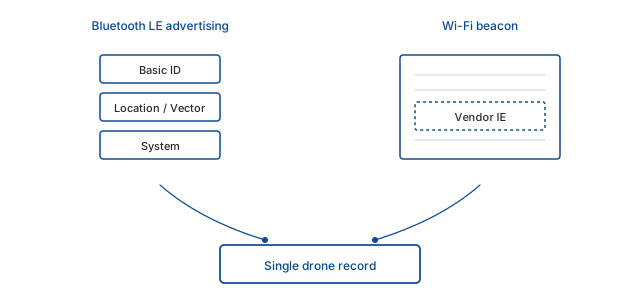
Remote ID over Bluetooth LE uses advertising packets on the primary channels. Because the legacy advertising data unit is limited in size, the ASTM F3411 standard fragments the Remote ID information across multiple message types — Basic ID, Location/Vector, System, Self-ID, and Operator ID — each transmitted in its own advertisement.
A receiving application must capture a sequence of these advertisements and reassemble them per drone. The framework's BLE scanning engine filters by service UUID and manufacturer data patterns defined for Remote ID, then caches messages per MAC address and fires an event as soon as enough data has been collected to present a coherent record.
Bluetooth 5 Extended Advertising eases this process. Larger payloads on the secondary advertising channels mean more information fits in a single burst, which reduces the time required to decode a complete drone record. Both legacy and extended advertising are fully supported.
Wi-Fi beacons
Remote ID over Wi-Fi works differently. The drone creates a soft access point and transmits standard 802.11 beacon frames at regular intervals embedding the Remote ID information in a vendor-specific information element. No packet injection or promiscuous mode is required — the Windows Native Wifi API can retrieve the complete set of information elements from each beacon without joining the network.
The framework issues periodic scans, extracts the Remote ID data element by its known Organizationally Unique Identifier, and parses the binary content according to ASTM F3411 or ASD-STAN. Because beacon frames are broadcast on both 2.4 GHz and 5 GHz bands, a standard dual-band adapter detects drones on either band without hardware modification.
Wi-Fi broadcasts also provide longer reception range than BLE. The higher transmission power of a soft AP means a laptop can detect drones at distances where BLE advertisements would already be lost in noise.
Protocol handling
The frameworks implement parsers for the complete set of message types defined by ASTM F3411 — Basic ID, Location/Vector, Self-ID, System, and Operator ID — as well as the ASD-STAN Direct Remote ID message structure. Each parser validates message headers, handles unknown or future message types gracefully, and never corrupts the data stream.
Beyond parsing, the library merges correlated messages from BLE and Wi-Fi transports. A drone transmitting over both media appears as a single logical entity, not two separate entries in the user interface. This is important for monitoring applications where duplicates would confuse the operator.
The data model exposed to the developer includes ID type, UAS ID, latitude, longitude, altitude, speed, heading, vertical speed, height above ground, operator location, and timestamp. That is enough to implement rich filtering, logging, and mapping without going back to the raw bytes.
Architecture and hardware
The frameworks expose an event-driven interface suitable for both interactive desktop applications and headless Windows services. After initializing a scanner and configuring a few parameters, the developer subscribes to events for drone detected, drone updated, and drone lost. Each event carries a strongly typed data structure with the full Remote ID information for that drone at that moment.
Scanning runs on background threads. The API supports filtering by transport — BLE only, Wi-Fi only, or both simultaneously. For Wi-Fi, the library manages scan intervals intelligently to balance detection latency against battery life and radio throughput, avoiding the pitfalls of continuous aggressive scanning that would interfere with the host's own network connection.
Hardware requirements are minimal. Any Bluetooth 4.0 or later adapter can receive legacy advertising Remote ID. Bluetooth 5 adapters are recommended for extended advertising and Coded PHY reception. Every Wi-Fi adapter that works with the standard Windows WLAN service can capture drone beacon frames. A standard business laptop with integrated Bluetooth and Wi-Fi running Windows 10 or 11 is a fully functional detection platform out of the box.
Applications
Remote ID reception on Windows unlocks a range of use cases, from law enforcement to commercial fleet management. What follows are the most common deployment patterns.
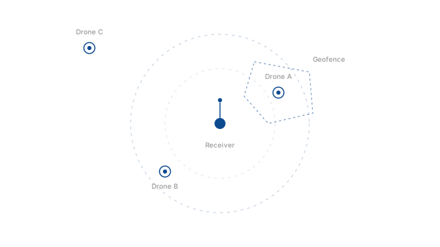
Public safety and event security. Officers responding to reports of a suspicious drone can launch a lightweight monitoring application that overlays detected drone positions on a map, showing the drone's ID, altitude, and flight path. At large public gatherings — sports events, concerts, political rallies — security command centers run continuous background scanning to detect any drone entering a temporary flight restriction zone.
Critical infrastructure. Power plants, water treatment facilities, airports, and prisons face a constant threat from unauthorized drone overflights that can be used for surveillance, smuggling, or payload delivery. Integrating the DRI frameworks into existing Windows-based security management systems provides an automated, always-on detection layer. When a drone is detected within a perimeter, the software triggers alerts, logs the drone's ID and trajectory, and can cue pan-tilt-zoom cameras to visually track the intruder.
Enterprise drone operators. Operators of commercial fleets — delivery, inspection, agriculture — use the frameworks as an independent ground-truth verification layer. A fleet management application built on Windows can listen for Remote ID broadcasts of every authorized drone in the air, cross-reference identifiers against the day's flight plan, and flag any drone broadcasting an unrecognized ID or operating outside its assigned geofence.
General aviation and urban air mobility. Pilots of manned aircraft operating at low altitudes — helicopters, crop dusters, air taxis — can use a tablet running drone detection software to gain awareness of nearby unmanned traffic. Vertiport operators and UAM traffic managers deploy monitoring stations that continuously scan for drones broadcasting their location, building a real-time map of cooperative airspace users. This supplements collision avoidance systems where visual line of sight is limited.
Emergency response. Temporary flight restrictions around forest fires, disaster zones, and major outdoor events require ad-hoc drone monitoring deployed quickly and with minimal setup. A portable kit — a Windows laptop, a high-gain USB Bluetooth adapter, a USB Wi-Fi adapter with external antenna, and the monitoring software — can be operational within minutes. The library works entirely locally, so no internet connection is required to receive and decode broadcasts.
Custom vertical applications. Independent software vendors and enterprise in-house teams build specialized products on top of the frameworks. A property management company can show tenants detected drone activity around a high-rise building. A university research team can study drone traffic patterns in urban environments. The event-driven architecture makes it straightforward to integrate drone detection data into larger platforms — physical security information management systems, smart city dashboards, or automated response systems that cue alarms, lock gates, or command drone mitigation hardware.
Getting started
The Wireless Communication Library provides a complete sample application on GitHub — btframework/Drone-Remote-ID — that demonstrates the entire pipeline: scanning BLE and Wi-Fi beacons, decoding raw messages, and displaying a list of detected drones with identifiers, latitude, longitude, altitude, speed, and heading.
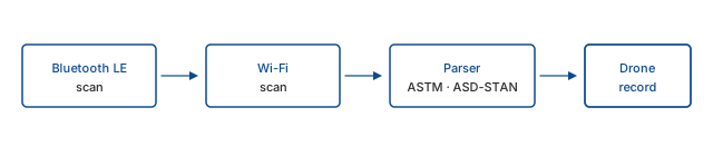
The sample is written in a clean, modular style. Even developers new to Remote ID can quickly understand how to initialize the library, subscribe to events, and shut down the scanning service gracefully. It includes all necessary library binaries and requires no additional drivers — clone the repository, build in Visual Studio, and start seeing drone detections from any compliant drone in radio range.
Running the sample reveals the framework's design. When a Bluetooth Legacy Advertising drone enters range, the application begins receiving Basic ID and Location/Vector messages almost immediately, with the caching mechanism assembling fragmented data into a coherent drone object. If a Wi-Fi broadcasting drone appears nearby, its details show up as well, with the transport method clearly labeled. Deduplication happens automatically when a drone transmits over both media.
Extending the sample into a production-ready solution is a natural progression. Add a background Windows service that logs all detections to a SQL database for compliance reporting. Integrate a map control to plot drone positions on a georeferenced canvas, using continuous update events to animate movement in real time. Layer geofencing logic on top: when a drone's position enters a prohibited polygon, send an alert, post to a REST endpoint, or activate a local alarm. The modular separation of concerns means the scanning and decoding logic can be transplanted directly into a headless service without a user interface.
Because all radio management and protocol parsing is handled by the library, development effort shifts entirely to domain-specific value. The heavy lifting of scanning, filtering, correlating, and decoding is already done. New features are built on top of a structured, standards-compliant data model rather than raw radio bytes.
Frequently asked questions
- What is Drone Remote ID?
- Drone Remote ID is a system that requires drones to broadcast identification and telemetry data during flight, acting like a digital license plate for unmanned aircraft. Airspace authorities, law enforcement, and private security use it to identify drones and trace them to their operators.
- How can I receive Drone Remote ID on Windows?
- The Bluetooth Framework and Wi-Fi Framework provide a high-level API that captures BLE advertisements and Wi-Fi beacons, parses ASTM F3411 and ASD-STAN messages, and delivers structured drone telemetry to your application. No special hardware is required beyond a standard Bluetooth and Wi-Fi adapter.
- Which standards does the library support?
- Both standards for broadcast Remote ID: ASTM F3411, used in the United States, and ASD-STAN prEN 4709-002, used in Europe. Both Bluetooth Low Energy and Wi-Fi beacon transports are supported for each standard.